Arches National Park
A Day Trip To Arches National Park
With a landscape that can only be described as a geological wonderland, Utah is the ultimate state for National Park hopping. Arches National Park is no exception, with stunning rock formations. It’s also the smallest National Park in Utah, so if you aren’t doing much hiking you can easily tackle the road-accessible portion in a single day.
Park Hopping in Utah: Essentials

Before tackling the park itself, it’s worth mentioning the state of Utah as a whole. It’s a large state, dotted with National Parks big and small, most of which exist in a desert climate. This means taking a few special precautions (as well as grabbing extra gear).
I made the mistake of allowing myself to become dehydrated my first night in Utah and it wasn’t pretty. After that, we purchased a four-gallon aqua trainer to keep in the car. This was great because it meant we could refill our hydration packs constantly without needing to hunt down a water source (also helpful when washing and cooking at camp). Trust me on this one: Drink more water than you think you need.
Another essential when driving through Utah is knowledge. The grandeur of Utah is typically visible through its rock formations, and understanding the geology goes a long way. This is one of the few states where owning a copy of Roadside Geology is basically mandatory. The parks are amazing, of course, but even a drive along the highway is full of beauty, and this book will help you identify formations as you drive. Following along is a great way to pass the time on a long road trip, and it allows you to gain a deeper appreciation of the landscape.
We kept our copy of this book opens during our entire road trip across the state. Our drive started in Grand Junction, Colorado, just minutes from the Utah border, and took us across the entire width of the lower half of Utah. We went through Arches National Park, Canyonlands National Park, Grand Staircase Escalante National Monument, Capitol Reef National Park, and Zion National Park. Throughout the entire trip, Roadside Geology of Utah helped us understand what we were seeing and the significance of how the landscape was formed.
Also Read: National Parks To Visit In Winter
Trip to Arches National Park
Arches itself is a small park, relatively speaking (by which we mean it’s only 76,000 acres, compared to neighboring Canyonlands National Park’s area of over 337,000 acres). It’s also an easy park to access, being close to the town of Moab (our thoughts on Moab: Great coffee shops, expensive hotels. Camping is recommended).
After heading into the park, you’ll pass the Visitor’s Center and follow the single main road. It leads from the entrance and through the park, eventually looping back on itself at the Devil’s Garden Campground. Only two additional roads shoot off from this main road, the first leading you to the Double and Window arches and the second taking you to the famous Delicate Arch (you know, the one on Utah’s license plate?).
Access a driving map of Arches National Park here.
Altogether, you’re looking at about 25-30 miles of driving within the park, with plenty of scenic overlooks to keep you busy. There are also a number of short hikes with trailheads directly off the road, giving you a chance to stretch your legs without committing to anything too strenuous.
If you commit to stopping at each viewpoint and taking one or two short hikes of half an hour or less you’re day trip to Arches National Park will probably last around 4 – 5 hours total. Each of the viewpoints is unique in its own way and we’ve highlighted a few of our favorites below.
Park Avenue Viewpoint
Upon entering the park you’ll find yourself driving up along an ancient fault line, gaining enough altitude to look over the freeway below and clearly see the different rock layers that define what is known as the Upper Colorado Plateau.
From there, the road takes you into the park, where you’re met with a number of turnoffs. The first official viewpoint you reach is Park Avenue, named for the building-like appearance of the vertical rock faces. This is also a trailhead, and the one-mile hike takes you among the giant stone monoliths. If you’re not up for the hike, or if it’s too hot, don’t worry. Most of the structures are visible from various viewpoints along the road.
La Sal Mountains Viewpoint
Even though these mountains are visible during a large portion of the drive-through Arches, it’s worth making note of them. First off, they’re just cool, geologically speaking. Looming off in the distance, they represent what’s known as a locality. Basically, instead of being formed by the meeting of two tectonic plates, these mountains are the result of volcanic magma. They aren’t volcanoes themselves, but a ripple of magma beneath the surface of the earth caused the ground to rise up, creating these mountains.
On a more practical note, the La Sal Mountains are your general indicator of cell service. If you can see the mountains, you probably have at least one bar. If the mountains are out of range, so is your cell phone.
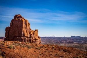
Courthouse Towers Viewpoint
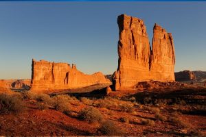
This is one of my favorite viewpoints in the park because there are so many different structures. You can see The Courthouse, The Organ, Sheep Rock, and, my personal favorite, the Three Gossips.
Of course, at this point, you’re probably starting to wonder where all the arches are. After all, this is called Arches National Park, not Monolith National Park. Don’t worry, we’re almost there. Patience, young grasshopper.
Balanced Rock

As far as park fame goes, Balanced Rock is seconded only by the Delicate Arch. The rock sits precariously atop a pillar, looking ready to topple at any moment. This, like everything else in the park, is the result of weathering. The pillar is made of a softer stone than the rock balanced on top. As a result, the pillar erodes away faster than the rock, giving it a balanced appearance. Eventually, the pillar will erode so far that the entire structure will collapse.
In fact, decades ago, there was a second balanced rock nearby, known as Chip Off the Old Block. It came crashing down in 1975, a testament to the constantly changing landscape.
Double Arch & The Windows
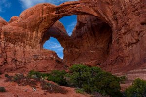
Finally, an arch! Actually, this viewpoint provides you with the largest collection of easily accessible arches in one place at the park.
You can reach these arches by taking one of only two side roads in the park. The road dead-ends in a parking lot, from which you can clearly see the arches. You can also take a short hike to any of them for a closer look.
Essentially, you have two hiking options. The most direct and quickest hike is to the Double Arch. This is a 0.25-mile flat hike taking you beneath the soaring rock of the Double Arch. It can be a hot hike, but the arch itself provides great shade and a nice place to relax and enjoy the scenery.
And, of course, climbing options. Which, being me, I had no choice but to undertake. Keep in mind: It’s illegal (and dangerous!) to climb on top of the arches themselves. There are plenty of other opportunities to scramble over Slickrock. Just be careful; the rock lives up to its name.
The second option is to hike to the Windows. This is also a short hike, with three different arches: North Window, South Window, and Turret Arch. While you get more bang for your buck over here the hike is ever so slightly more strenuous (it’s still not bad. We’re talking maybe a half-mile to a mile, depending on whether you visit one or all three arches).
I definitely recommend hiking at least one of these trails. It’s an easy trek and the best opportunity to get up close and personal with the arches during a day trip.
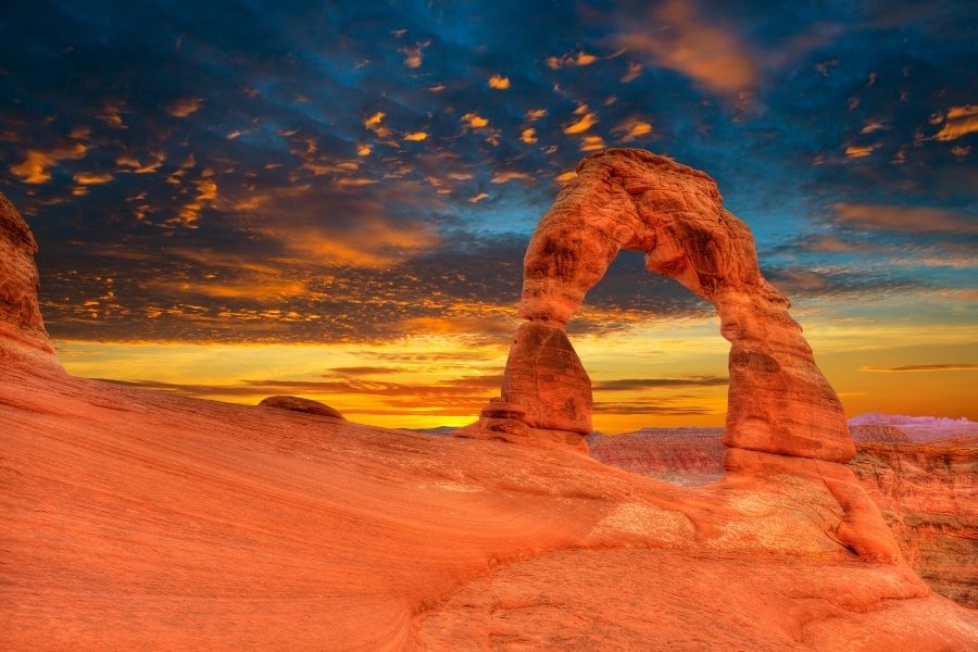
Delicate Arch
By far the most famous arch in the world, the Delicate Arch is situated along the second side road. Unlike the previous arches, this one isn’t visible from the road, so you will have to do some walking.
If you’re looking to incorporate Delicate Arch into your day trip you can visit the Delicate Arch Viewpoint. Take the side road until it dead-ends into a parking lot with two options. The easiest option is a quick 100-yard walk. You’ll be able to see the arch, about a mile away. For a less obstructed view, continue along the trail for half a mile (with stairs) to the Upper Delicate Arch Viewpoint. This viewpoint will give you a clear view of the arch, half a mile in the distance.
If you’re dead set on seeing Delicate Arch up close and personal, you’ll have to commit to a more strenuous hike. The viewpoints are close to the arch, but reaching them is impossible due to a large canyon. Instead, you’ll need to drive to the trailhead parking lot and take a three-mile hike to the base of the arch. This hike is marked as a difficult trail with little to no shade and narrow ledges. If you’re feeling adventurous, make sure you block out at least three hours for this hike and take plenty of water.
Devil’s Campground
After seeing Delicate Arch, you’ll hook back up with the main road. I’ll be honest, at this point in our journey, we were getting a bit tired. Our day trip to Arches National Park was fast approaching evening (we got a late start), so we streaked through the last portion of the drive. This last stretch of roadway will take you past a number of viewpoints and short hikes, including the Salt Valley Overlook, the Sand Dune Arch, and the Broken Arch.
Of these, the viewpoints are worth a brief stop for a photo op. There are interesting formations, and if you’re still up for hiking the Sand Dune Arch offers a short trail with shade. It’s named due to the sandy terrain surrounding it, so take care when hiking. It’s not a far walk, but it’s harder than walking on flat ground. This was our last hike of the day and the shade provided a welcome break.
The main road finally dead-ends at the Devil’s Campground. Here, you’ll find the trailhead for one of the most strenuous hikes in the park–a 7.2-mile primitive trek to the Double O Arch, estimated to take 4-5 hours. Odds are you won’t be making this hike on a day trip, so this is where you’ll turn around and begin the drive back to the park entrance.
Making the most of a day trip to Arches National Park
With so much to see right from the road, Arches is a great park for a day trip. I do recommend at least 1-2 short hikes (my preference would be for Double Arch and Upper Delicate Arch) to stretch your legs and witness the famous arches up close and personal.
If you choose not to get out of the car at all, the drive will probably take you about an hour to an hour and a half.
Also Read: Corbett National Park
Tips for an extended stay
If you’re staying near the park for more than a day, there is a hiking guide available on the park’s website. Additionally, if you’re in the area for a few days, I recommend taking time to visit neighboring Canyonlands National Park. It’s much larger, with stunning canyons visible from the road. Outside of the parks, there are plenty of attractions for the paleontology enthusiasts (but that’s another post for another day). Let’s just say you won’t be disappointed.
As far as lodging is concerned, we highly recommend taking advantage of the many campsites available. We only stayed in a hotel one night (the night I got dehydrated), and it cost us over $100. On the flip side, the nights we spent camping cost us $0-$10 (depending on the location) and we woke to amazing views.
Our wonderful campsite on BLM land along the Colorado River, just outside of Moab.
Finally, don’t forget to consult your Roadside Geology of Utah book along the way. It goes beyond the parks, allowing you to appreciate all of the geology of Utah as you leave Arches and continue driving through the state.